Project Description

The current project intends to use the heritage of the CAWA project as well as the recent advancements realized within the GRASP-Open software package to establish and extend the concept for generating synergy MERIS+AATSR products.

Thus, the scope of this project is to fully develop a synergy MERIS+AATSR retrieval scheme, to test it, and to eventually apply it to the full archive of MERIS and AATSR data. This GRASP/MERIS+AATSR data set is then to be validated against AERONET as reference and intercompared with other satellite-derived data sets, including existing MERIS+AATSR synergy data where available.

In addition, an optional activity of this project is to update the MERIS/GRASP and to extend the AATSR/GRASP retrieval schemes and to process the full archives of MERIS and AATSR individually to generate an updated MERIS/GRASP dataset and a new AATSR/GRASP data set. These data sets are expected to be analyzed individually and compared to the synergy MERIS+AATSR data with the purpose of improving the understanding of the information content of each instrument and the value added of MERIS+AATSR synergy processing. These individual products will serve the community when they want to use a single-instrument data set, e.g. for intercomparison exercises.

Proposed Approach

This project has the following work logic:


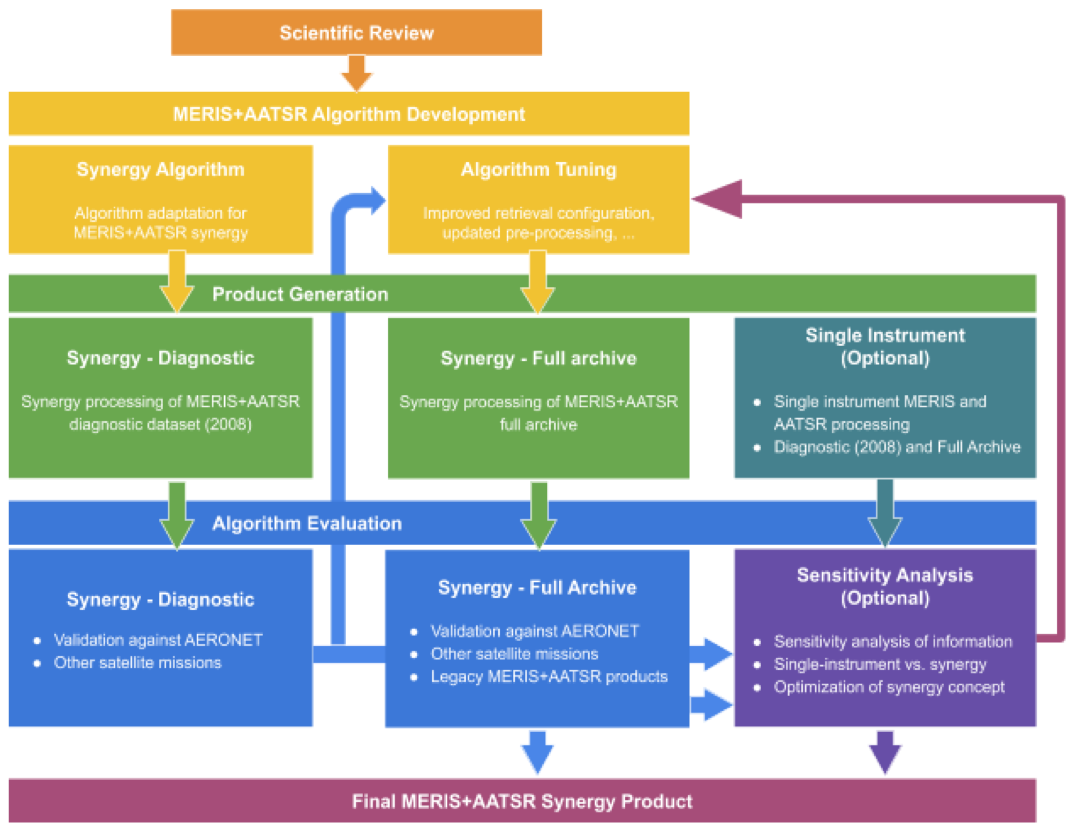
1. As requested in the SOW, the study will be based on an in-depth scientific review of the state-of-the-art related to the retrieval of AOD from MERIS and AATSR instruments and consolidate a requirements baseline.

2. The core GRASP algorithm will be adapted to inversion of MERIS+AATSR data. This will include:

  • The adaptation to spectral specifications of the instrument, adjusting and tuning the forward model and inversion of GRASP
  • Pre-processing and preparation of the MERIS and AATSR data
  • Based on the evaluation of the diagnostic dataset and a better understanding following the sensitivity analysis (optional), the synergy MERIS+AATSR algorithm will be further tuned.

3. The developed MERIS+AATSR algorithm will be applied to the MERIS and AATSR data to generate products for

  • A diagnostic dataset for the year 2008 using the initial version, and
  • A full archive dataset using an update version of the algorithm.
  • A diagnostic dataset (2008) and a full-archive dataset for single-instrument MERIS- only and AATSR-only (optional).

4. The generated products will be analyzed to evaluate the algorithm performance using a variety of datasets. This will utilize

  • AERONET as ground-based reference, PARASOL and MODIS as satellite
  • The legacy MERIS+AATSR products for comparison.
  • The evaluation of the diagnostic product will be used to improve the algorithm for the full archive processing
  • A Sensitivity Analysis will rigorously compare the single instrument products with the synergy products to provide a better understanding of the information content of the individual instruments and the optimal synergy setup (optional).

5. Based on the outcome of evaluation of the full archive of MERIS+AATSR/GRASP product the conclusion about the data quality and recommendation for Sentinel-3 synergy algorithm development will be finalized and formulated.

The shown chart depicts the work logic of this study.

Project Consortium

GRASP EARTH shorten from ‘Generalized Retrieval of Atmosphere and Surface Properties” is a company that was founded in February 2015 with the main goal of development of remote sensing algorithms and scientific methods for environment studies of atmosphere and surface of the Earth. The initial idea of GRASP has been developed by the efforts of CNRS and University of Lille. Then this base scientific concept has been realized in open-source GRASP-OPEN software adapted to diverse remote sensing applications. The main GRASP SAS activities cover a wide range of remote sensing topics: –       Developments of algorithms for advanced atmosphere and surface characterization from passive and active ground based and space-borne remote sensing. –       Scientific consulting in environmental studies. –       Distribution and support of GRASP open source code. Since its creation, GRASP SAS has been involved in collaboration with world-wide environmental public organizations and private companies, universities and the largest space agencies (ESA, EUMETSAT, NASA, JAXA) with the goal to improve the scientific knowledge of the atmosphere and surface properties, which have an essential impact on Earth climate, and tightly interconnected with human activities. The GRASP code was developed for advanced aerosol and surface retrieval from remote sensing measurements. GRASP SAS is composed by a unique team with full understanding all aspects of the code: physical and mathematical basis, software optimization etc. GRASP team has leaded several projects to retrieve atmosphere and surface parameters from different satellite sensors (PARASOL, MERIS, Sentinel 3 and 4, 3MI).

Cloudflight Austria GmbH was founded as Catalysts GmbH in 2007 and has grown to over 400 employees distributed over offices in Austria, Germany, Romania and The Netherlands. We develop individual software solutions for industry, agencies, and the public sector focusing on Big Data and Machine Learning (batch processing of Tera- and Petabytes, process of data streams in real time or near real time), High Performance Computing (acceleration of algorithms), and Large-Scale Agile Projects (large-scale agile software projects „On Time & On Budget“). Cloudflight’s large international customer base includes Porsche/Volkswagen, Fraport, DB, Raiffeisen, EUMETSAT, and the European Space Agency. Our customers value our solid problem-solving competence so that they can grow further. Cooperation exists with several national and international universities, including the Technical Universities of Vienna and Graz, the LOA at the University of Lille, the Free University of Berlin, the Kindai University in Osaka, the Austrian Met-Office ZAMG, the Austrian Environmental Agency Umweltbundesamt, the German DLR, and NASA. As part of the consortium carrying out the “Sentinel-4 Level 2 Processor Component Development” project for ESA, Cloudflight is providing the prototype and operational processors for surface and aerosol optical depth for the Sentinel-4 mission using the GRASP algorithm. The processors will be integrated in EUMETSAT’s MTG Level 2 Processing Facility. In the frame of the ESA CAWA project, “Advanced clouds, aerosols and water vapor products for Sentinel-3” the MERIS/Envisat full mission and 6 months of OLCI/S3A were reprocessed using GRASP as precursor for improved Sentinel-3 L2 products. In the frame of the EUMETSAT study “Study on Optimization of the GRASP Algorithm for the 3MI L2 Aerosol Retrieval”, Cloudflight and GRASP SAS are preparing the integration of the GRASP algorithm into the EPS-SG ground segment as operational Level 2 processor for Aerosol and Surface Reflectance for the Multi-viewing Multi-channel Multi-polarization Imaging instrument, 3MI. 3MI can be considered an operational successor of the PARASOL mission, and will provide the best basis for future aerosol characterization from satellites. In the frame of the “GRASP Cloud project” tasked by the Beyond Europe Initiative of the Austrian Federal Ministry of Science, Research, and Economy, BMWFW, Cloudflight is developing a cloud service for data processing using the GRASP algorithm, together with GRASP SAS (France), EODC (Austria), NASA (JPL and GSFC, USA), Airphotons (USA), Kindai University (Japan), and RADI (China). The service offered by the GRASP Cloud is the processing of Satellite, Ground-Station, and in-situ observations for public agencies and private enterprises.

Publications

De Leeuw, G.; Holzer-Popp, T.; Bevan, S.; Davies, W.; Descloitres, J.; Grainger, R.G.; Griesfeller, J.; Heckel, A.; Kinne, S.; Klüser, L.; et al.: Evaluation of seven European aerosol optical depth retrieval algorithms for climate analysis, Remote Sens. Environ, 162, 295–315, 2015.

Dubovik, O., Herman, M., Holdak, A., Lapyonok, T., Tanré, D., Deuzé, J. L., Ducos, F., Sinyuk, A., and Lopatin, A.: Statistically optimized inversion algorithm for enhanced retrieval of aerosol properties from spectral multi-angle polarimetric satellite observations, Atmos. Meas. Tech., 4, 975-1018, 2011.

Dubovik, O., T. Lapyonok, P. Litvinov, M. Herman, D. Fuertes, F. Ducos, A. Lopatin, A. Chaikovsky, B. Torres, Y. Derimian, X. Huang, M. Aspetsberger, and C. Federspiel: GRASP: a versatile algorithm for characterizing the atmosphere, SPIE: Newsroom, Published Online: September 19, 2014.

Holzer-Popp, T., G. de Leeuw, J. Griesfeller, D. Martynenko, L. Kluser, S. Bevan, W. Davies, F. Ducos, J. L. Deuzé, R. G. Graigner, A. Heckel, W. von Hoyningen-Hüne, P. Kolmonen, P. Litvinov, P. North, C. A. Poulsen, D. Ramon, R. Siddans, L. Sogachev, D. Tanre, G. E. Thomas, M. Vountas , J. Descloitres, J. Griesfeller, S. Kinne, M. Schulz, and S. Pinnock: Aerosol retrieval experiments in the ESA Aerosol cci project, Atmos. Meas. Tech., 6, 1919–1957, 2013.

Popp T., G. de Leeuw, C. Bingen, C. Brühl, V. Capelle, A. Chedin, L. Clarisse, O. Dubovik, R. Grain- ger, J. Griesfeller, A. Heckel, S. Kinne, L. Klüser, M. Kosmale, P. Kolmonen, L. Lelli, P. Litvinov, L. Mei, P. North, S. Pinnock, A. Povey, C. Robert, M. Schulz, L. Sogacheva, K. Stebel, D. Stein Zweers, G. Thomas, L. Gijsbert Tilstra, S. Vandenbussche, P. Veefkind, M. Vountas and Y. Xue: Development, Production and Evaluation of Aerosol Climate Data Records from European Satellite Observations (Aerosol_cci), Remote Sens., 8, 421, 2016.

Data

The data will be available soon.